<?xml version="1.0" encoding="utf-8"?>
<feed xmlns="http://www.w3.org/2005/Atom">
  <title>hiking</title>
  <link rel="alternate" type="text/html" href="http://tumbleweed.org.za/tags/hiking"/>
  <link rel="self" type="application/atom+xml" href="http://tumbleweed.org.za/taxonomy/term/36/atom/feed"/>
  <id>http://tumbleweed.org.za/taxonomy/term/36/atom/feed</id>
  <updated>2007-12-29T19:44:20+00:00</updated>
  <entry>
    <title>Dark Gorge B</title>
    <link rel="alternate" type="text/html" href="http://tumbleweed.org.za/hiking/dark-gorge-b" />
    <id>http://tumbleweed.org.za/hiking/dark-gorge-b</id>
    <published>2007-12-31T16:10:00+00:00</published>
    <updated>2007-12-31T16:10:24+00:00</updated>
    <author>
      <name>tumbleweed</name>
    </author>
    <category term="hiking" />
    <category term="Howto" />
    <category term="table-mountain" />
    <summary type="html"><![CDATA[<p>Time: 3-4hrs<br />
Last Hiked:&nbsp;Jan&nbsp;2006</p>

<p>Very steep and rather eroded. Beautiful forest in the ravine most of the&nbsp;way&nbsp;up.</p>

<p>Start at Newlands forestary Station, and take the path up to the base of&nbsp;Newlands&nbsp;Ravine.</p>

<p>Go right along the contour path until you reach the first river up (only about 50m away)
This is dark gorge. Follow the&nbsp;cairns&nbsp;up.</p>

<p>The only thing you have to worry about is not going up Dark Gully. When you reach the fork of the
valleys,&nbsp;stick&nbsp;left.</p>

<p><img src="/files/dark-gorge-map.jpg" alt="Dark Gorge Map" /></p>
    ]]></summary>
    <content type="html"><![CDATA[<p>Time: 3-4hrs<br />
Last Hiked: Jan&nbsp;2006</p>

<p>Very steep and rather eroded. Beautiful forest in the ravine most of the way&nbsp;up.</p>

<p>Start at Newlands forestary Station, and take the path up to the base of Newlands&nbsp;Ravine.</p>

<p>Go right along the contour path until you reach the first river up (only about 50m away)
This is dark gorge. Follow the cairns&nbsp;up.</p>

<p>The only thing you have to worry about is not going up Dark Gully. When you reach the fork of the
valleys, stick&nbsp;left.</p>

<p><img src="/files/dark-gorge-map.jpg" alt="Dark Gorge Map" /></p>
    ]]></content>
  </entry>
  <entry>
    <title>Window Gorge D</title>
    <link rel="alternate" type="text/html" href="http://tumbleweed.org.za/hiking/window-gorge-d" />
    <id>http://tumbleweed.org.za/hiking/window-gorge-d</id>
    <published>2007-12-31T15:26:47+00:00</published>
    <updated>2007-12-31T15:26:47+00:00</updated>
    <author>
      <name>tumbleweed</name>
    </author>
    <category term="hiking" />
    <category term="Howto" />
    <category term="table-mountain" />
    <summary type="html"><![CDATA[<p>This Description comes from Tony Lourens - Table Mountain Classics,&nbsp;with&nbsp;ammendments.</p>

<p>Rope&nbsp;Recommended</p>

<p>Time: 5-6hrs<br />
Last Walked:&nbsp;Dec&nbsp;2005</p>

<p>This is rather an eroded and seldom used route, but has some magnificent pools
and good scrambles. It&#8217;s mostly shaded, so a hot day would be a good choice.
The scrambles aren&#8217;t hard but quite exposed, and have loose grips (because they
haven&#8217;t seen enough traffic to break all the loose&nbsp;grips&nbsp;off).</p>

<p>This isn&#8217;t an easy route if you don&#8217;t know it,&nbsp;and&nbsp;dangerous.</p>
    ]]></summary>
    <content type="html"><![CDATA[<p>This Description comes from Tony Lourens - Table Mountain Classics, with&nbsp;ammendments.</p>

<p>Rope&nbsp;Recommended</p>

<p>Time: 5-6hrs<br />
Last Walked: Dec&nbsp;2005</p>

<p>This is rather an eroded and seldom used route, but has some magnificent pools
and good scrambles. It&#8217;s mostly shaded, so a hot day would be a good choice.
The scrambles aren&#8217;t hard but quite exposed, and have loose grips (because they
haven&#8217;t seen enough traffic to break all the loose grips&nbsp;off).</p>

<p>This isn&#8217;t an easy route if you don&#8217;t know it, and&nbsp;dangerous.</p>

<p>
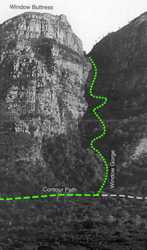
Start at Kirstenbosch Old Main Gate, and take Smuts Track to the Countour Path.
Turn right and walk for about ten minutes to a little wooden bridge.
Immediately after this you will see an obvious bouldery ravine on your left.
This is Window Gorge. If you go too far you will come to the start of the
zig-zags on Fernwood Buttress, just a minute or two past the&nbsp;ravine.</p>

<p>Ascend the bouldery gorge for about ten minutes past some small pools, to a
point just before some waterfalls where you will see a small stone scree
pouring in from the right (huge cairn). Take the scree to a big subsidiary
gully (cairn). Do not follow the gully, but go up the steep slope to its left.
Continue up the slope, keeping in between the gully on your right and the gorge
proper on your left, to reach the high&nbsp;rockband.</p>

<p>Traverse to the left and descend an earthy chute to an obvious tree on the
corner (cairn). Step down and traverse over a drop to reach easy slopes leading
into the ravine&nbsp;bed.</p>

<p>Follow the ravine for about 15 to 20 minutes to a big waterfall. Break out
to the right up a broken slope (cairn) for about five minutes to another cairn.
At this point go up to the rockband, crossing a large boulder-field and
climb a step to a&nbsp;tree.</p>

<p>Traverse off to the left and go up to a ledge beneath steep rock. Here you
make another long traverse to the left which leads back into the ravine.
At the last tree before the traverse comes to a treacherous end, there is a
cairn and a stick pointing you up the rock-band.Continue up to a beautiful pool
beneath a large waterfall (620 m elev). This is the best swimming spot and
makes an ideal lunch&nbsp;break.</p>

<p>Scramble up and around the corner on your right (cairn), through some trees,
and up a break to a shoulder (cairn). From here traverse to the left until able
to climb the exposed step to a ledge. Traverse right to a big tree. Continue
traversing to the right to an obvious flake-type break going off to the left
(cairn). Climb this to a ledge (`D&#8217;), and walk to the left to two trees. From
this point you can see a magnificent rock pinnacle high up in the&nbsp;ravine.</p>

<p>Climb the easy break above, to trees on the right. Make an awkward step up,
and traverse left past a big tree into the ravine bed above the big&nbsp;waterfall.</p>

<p>Climb a long `C&#8217; grade pitch just to the right of the mossy water chute to
the top of the waterfall, passing a cairn to a clump of&nbsp;trees.</p>

<p>Continue up the ravine to what appears, at first glance, to be an
impassable, mossy waterfall. On closer inspection you will see a window at the
top formed by a jammed block (which gives the gorge its name). Climb up to and
through the window, enabling you to carry on up the ravine to the last little
waterfall, which is bypassed via the dirty wall immediately to the right.
Continue past two old rusty sign-posts to the top, and gain the main path which
is literally metres&nbsp;away.</p>

<p><img src="/files/window-gorge-face.jpg" alt="Window Gorge Face" />
<img src="/files/window-gorge-map.jpg" alt="Window Gorge Map" /></p>
    ]]></content>
  </entry>
  <entry>
    <title>Left Face B</title>
    <link rel="alternate" type="text/html" href="http://tumbleweed.org.za/hiking/left-face-b" />
    <id>http://tumbleweed.org.za/hiking/left-face-b</id>
    <published>2007-12-29T19:42:07+00:00</published>
    <updated>2007-12-29T19:44:20+00:00</updated>
    <author>
      <name>tumbleweed</name>
    </author>
    <category term="hiking" />
    <category term="Howto" />
    <category term="table-mountain" />
    <summary type="html"><![CDATA[<p>Time: 2-3 hours<br />
Last walked:&nbsp;Dec&nbsp;2005</p>

<p>Left face B is a very pleasent alternative to Platteklip (which let&#8217;s face it, we&nbsp;all&nbsp;hate).</p>

<p>It winds up across the left face of the mountain, across sheer looking cliffs and rock bands - a
truly improbably looking route. But the hike itself isn&#8217;t exposed, and only contains a pitch&nbsp;or&nbsp;two.</p>

<p>Start up Platteklip gorge, pass the contour path, and continue until the last left side corner
before the path heads up into the gorge proper. This corner has a vertical section, with a large rock at&nbsp;the&nbsp;base</p>
    ]]></summary>
    <content type="html"><![CDATA[<p>Time: 2-3 hours<br />
Last walked: Dec&nbsp;2005</p>

<p>Left face B is a very pleasent alternative to Platteklip (which let&#8217;s face it, we all&nbsp;hate).</p>

<p>It winds up across the left face of the mountain, across sheer looking cliffs and rock bands - a
truly improbably looking route. But the hike itself isn&#8217;t exposed, and only contains a pitch or&nbsp;two.</p>

<p>Start up Platteklip gorge, pass the contour path, and continue until the last left side corner
before the path heads up into the gorge proper. This corner has a vertical section, with a large rock at the base
with a feint path leading out - this isn&#8217;t right. Rather at the top of the corner, is a large bush with the path
behind it. Head up&nbsp;here.</p>

<p>Follow the path up the slope to the lower rock-bands. Ascend an open gully immediately to the right of a
yellowish rock scar. From here traverse to the right for about five to ten minutes to a point where you can
ascend some easy rock steps for about 60 metres. (Take care not to traverse too far before before you start
ascending, as this will take you to very steep ground overlooking Platteklip&nbsp;Gorge).</p>

<p>After this traverse to the right for a while until further progress seems impractical.
Here a short and easy rock pitch allows you to gain the next grassy terrace. At this
point a grassy gully leads down to Platteklip Gorge (good escape route).
On the left side of the terrace is a steep narrow gully which is badly eroded in places.
Ascend this gully, moving to the left near the top, and continue up to a shoulder from
where the rest of the climb can be easily scrutinised. Traverse distance to the left on
a grassy strip, passing the &#8216;Centre Left Face&#8217; route where the traverse becomes quite narrow.
Continue traversing for some time then, after ascending some easy rock to a higher level,
climb a short pitch. From this point follow the path leading to the right to a rock-face
where the traverse narrows somewhat, and you encounter a simple step-over. From the grassy
terrace around the corner follow one of a few easy ways to the&nbsp;top.</p>

<h2>Maps</h2>

<p><img src="/files/left-face-b-face.jpg" alt="Left Face B Face" />
<img src="/files/left-face-b-map.jpg" alt="Left Face B Map" /></p>
    ]]></content>
  </entry>
</feed>
